History
Overview by Tom DeBlack
Thomas A. DeBlack is a retired Professor of History at Arkansas Tech University in Russellville. This article is an excerpt from his 1995 doctoral dissertation at the University of Arkansas. The dissertation is the basis for a forthcoming book.
In 1831, forty-year-old Joel Johnson, the scion of a large and prestigious Kentucky family, sold his house and grist mill in Scott County, Kentucky, and, leaving behind a wife and five children, set off for Chicot County in the southeasternmost part of the Arkansas territory. The southern expanse of the Arkansas delta that Johnson entered in 1831 was a foreboding frontier wilderness. Bordered by Louisiana on the south and by the Mississippi River on the east, the county’s name may have originated with French riverboatmen of an earlier era who referred to the snags that threatened their boats as “chicots,” the teeth of the river. The Mississippi played a crucial role in the life of Chicot County. Like the Indians who came before them, the earliest white residents of the county settled along its banks and became familiar with its geography and unpredictable nature. They gave it names which reflected their mixed feelings toward it–Old Man River, Old Devil River, Old Big Strong.
The land which bordered the river was described by an early resident as “showing to perfection nature’s grand handiwork, replete with towering forest trees of every wood valuable in commerce.” Nourished by the Mississippi and other streams, the incredibly fertile soil would make the delta one of the most productive agricultural regions in the world.
But, as historian Willard Gatewood has pointed out, “The same rivers and bottomlands that nourished the Delta’s economy also jeopardized public health. Mosquito-borne malaria was a constant threat to inhabitants; contaminated water spread cholera and dysentery; and the damp climate contributed to a host of respiratory ailments that were a principal cause of death.” Floods menaced those living along the river. Natural levees formed along the river’s channel, but they often proved insufficient to hold back the raging water. When the river flooded, the water raced over these barriers and was trapped on the backside of the levee. The result was a backswamp, a permanent or semipermanent body of water that was home to cypress and tupelo trees.
Early travelers to the region noted the strong sense of foreboding that these swamps exuded. “No prospect on earth can be more gloomy,” wrote Timothy Flint, an early nineteenth-century missionary. “[A] cypress swamp, with its countless interlaced branches, of a hoary grey, has an aspect of desolation and death.” The sense of foreboding was more than just visual. Flint observed, “The musquitoes [sic] swarm above the water in countless millions. A very frequent adjunct to this horrible scenery is the moccason [sic] snake with his huge scaly body lying in folds upon the side of a cypress knee; and if you approach too near, lazy and reckless as he is, he throws the upper jaw of his huge mouth almost back to his neck, giving you ample warning of his ability and will to defend himself.”
Travel through the swamp was a daunting task. “I travelled forty miles along this river swamp, and a considerable part of the way in the edge of it, in which the horse sunk at every step half up to his knees,” the missionary noted. “Nothing interupted [sic] the death-like silence, but the hum of mosquitoes.”
Beyond the swamps, prospects for travel improved only slightly. An early resident of Chicot County described the surrounding land as “a dense forest of huge trees, oaks, gum, cotton-wood, hickory, pecan, elm, cypress, pine, and other varieties of forest growth. This wilderness was [made] almost impenetrable by large dense canebrakes, a variety of luxuriant vines, wild grape, muscadine, and other nonbearing fruit vines. . . . It took a stout heart [and] much bravery to enter and establish a claim in this dense, wooded wilderness.” Trails through the wilderness were forged by chipping barks from trees, forming “bridle paths” that made travel by horse possible. But, this resident noted, “Between settlements vast swamps, [and] streams without bridges prevented frequent intercourse or business of the people.”
The paradox in the nature of the land was reflected in the people of the region. “In this solitude,” an early resident noted, “were found very worthy cultivated people, as well as some very bad characters.” An early Arkansas political figure (who lived to regret the remark) observed that “every man left his honesty and every woman her chastity on the other side of the Mississippi River, on moving to Arkansas.” The territory quickly developed a reputation for violence and lawlessness. Missionaries who traversed the region in the early 19th century were appalled at the conditions they found. A Congregational minister noted, “It is painful to witness the deplorable state of morals in this place. The Sabbath is awfully profaned; idleness, drinking, swearing, and gambling almost universally prevail.”
The early white settlers of the region exploited what the historian Walter Prescott Webb called the “primary windfalls,” the wild game, fur-bearing animals, and fish that abounded in the area. But the second generation of white settlers, of which Joel Johnson was a part, was concerned with the “secondary windfalls,” the abundant timber and the incredibly fertile land. Their arrival would dramatically alter the natural and social landscape of the delta.
Many of those who came to the trans-Mississippi frontier envisioned establishing plantations like those in the more settled southeastern states. In the Arkansas delta in 1830, however, this dream of a sprawling plantation served by large numbers of black slaves was difficult to realize. Before the fertile land could produce a crop, it had to be “cleared” of trees and underbrush. Even after the clearing was accomplished, it took years of additional “grubbing” away bushes, clearing stumps, and leveling to make a field smooth.
The first generation of planters was often able to clear only enough land to raise a small crop. The more land that could be cleared, the larger the crop that could be planted, and the greater the potential profits to be made. In the years to come, those profits, and the power and prestige that accompanied them, would be derived from three major sources–ownership of large tracts of rich river land, ownership of black slaves to provide a reliable source of cheap labor, and the production of a cash crop. In this part of the delta, that crop was cotton.
In 1830 Chicot County’s population stood at only 1,165. Of that number, 888 (76.2%) were free whites, 270 (23.2%) were black slaves, and 7 (.6%) were free persons of color. The percentage of slaves was considerably higher than it was in the state as a whole, but significantly lower than in the nearby slave states of Alabama, Mississippi, and Louisiana. Slaveowners were only a small minority of the county’s population, and those who did own slaves owned only a few. Census records indicate that only two men in the county owned twenty slaves, the generally accepted minimum number to be considered a “planter.” When Joel Johnson arrived in the county in 1831, his twenty-three slaves made him the largest slaveowner in the county.
Johnson purchased a tract of land southeast of Old River Lake (present-day Lake Chicot) just above a large oxbow curve in the river called American Bend. The plantation he developed there was named Lakeport after a nearby steamboat landing.
For the next fifteen years Johnson expanded his holdings in land and slaves and brought more land under cultivation. The soil produced abundantly, and slave-based plantation agriculture became firmly entrenched in Chicot County. An 1839 map of the region showed approximately fifty plantations along the river and the area around Old River Lake. The census figures for 1840 revealed that the county’s population had risen to 3,806, but whites, who had comprised 76.2% of the population in 1830, now accounted for only 29% (1,105), while black slaves, who made up only 23.2% of the county’s population in 1830, now accounted for 70.9% (2,698) of the total.
By the time of his death in June 1846, Joel Johnson owned over 3,700 acres of rich delta land and ninety-five slaves. His estate was divided among his six surviving children, with his eldest son, Lycurgus Leonidas Johnson, receiving the largest share. Lycurgus was twenty-eight years old when his father died. Born in 1818 in Scott County, Kentucky, he joined his father in the Arkansas delta in the mid-1830s and acquired land just south of his father’s Lakeport holdings. In January 1842, Lycurgus married Lydia Taylor. The union produced twelve children, four of whom died before reaching age three.
To the casual observer, Chicot County at the time of Joel Johnson’s death might have seemed little different from the wilderness frontier he had found there fifteen years before. Crude roads had begun to replace the “bridle paths” that linked the county’s settlements, and, as early as 1835, a contract had been let to clear a road all the way to the state capital in Little Rock.
But dense forests and thick undergrowth still covered much of the county, making travel difficult. An early resident recalled that, as late as 1847, it was common to see men and women traveling by horseback through the forests, the young ladies riding side saddle, accompanied by an attendant, and carrying their wardrobes in a “carpet-bag” suspended from the saddle’s right horn. When it rained overland travel became virtually impossible. After one downpour in February 1849, a resident noted in his journal, “[T]his afternoon I have been to town with Richard[.] [W]e had to ride as much as a mile in water from six inches to four feet deep.”
The county seat, Columbia, was still a crude village. “It has some four or five stores[,] a tavern or two and some thirty or forty houses,” a citizen of the county wrote in December 1848. “It has no Church and no Court house if we except an old dilapidated building which is used for one.” Malaria and cholera were still common, especially in the “fever season” of summer and early fall. Steamboats remained the county’s principal link to the outside world.
Yet, in spite of poor roads, disease, and other discomforts, the growing demand for cotton meant growing prosperity for Lycurgus Johnson and other Chicot County planters. While a legal challenge kept Joel’s estate tied up in litigation for several years, the 1850 census still showed Lycurgus with 2,850 acres and ninety-five slaves. Those holdings and his father’s estate, which Lycurgus administered, combined to produce 7,000 bushels of corn, 742 bales of cotton, and 400 bushels of sweet potatoes, in addition to Irish potatoes, peas, beans, wool, and honey.
That same year Chicot County planters produced 12,192 bales of cotton, almost a fifth of the state total, and the cash value of county farms reached $1,324,607. Still, only 29,886 acres of county land was listed as “improved,” while 103,362 remained “unimproved.” Of Lycurgus Johnson’s 2,850 acres, only 650 were improved.
Slavery also continued to grow in the county. Between 1840 and 1850, the white population of the county increased by a net total of only seven people, while the slave population increased by 1,286. Blacks outnumbered whites in the county by almost four to one, and Chicot surpassed every other county in the state in proportion of slaves to total population. Sixty men now owned twenty or more slaves, and eight owned over a hundred.
The fortunes of Chicot County planters rose and fell with the price of cotton. In the mid-1840s, cotton prices declined and remained low through the mid-1850s. But in 1856, the price rose by over three cents per pound to 12.4 cents, the highest level since 1838. Prices for the years 1856-1860 averaged 11.4 cents per pound. “If cotton will only hold present prices for five years,” one state newspaper proclaimed in May of 1857, “Arkansas planters will be as rich as cream a foot thick.”
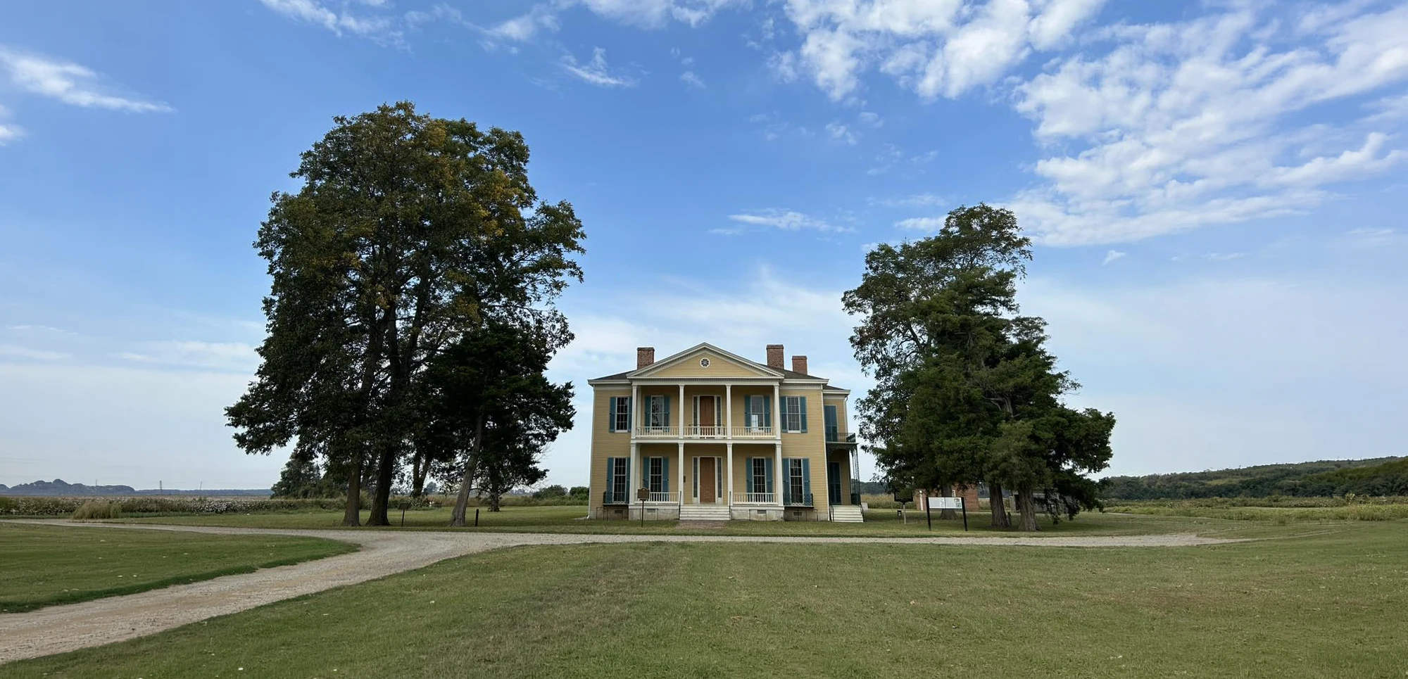
For Lycurgus Johnson, that prediction was coming true. Improvements to the levee system lessened the threat of overflows and dramatically increased the value of plantations near the river. In May 1857, a favorable legal settlement enabled Joel’s widow and his children to gain complete control of his estate. Lycurgus was able to add the Lakeport portion of the estate to his holdings. By the end of the decade, he owned over 4,400 acres of land and 155 slaves. This large labor force allowed him to further transform the delta wilderness into a productive cotton-growing operation. In 1858 Johnson began the construction of a large plantation house at Lakeport. The house, built in a modified Greek Revival style, was an imposing two-story, L-shaped structure containing seventeen rooms and measuring sixty-six feet long and forty-four feet wide. Constructed largely of cypress from the surrounding region and situated amidst the surrounding cotton fields, the mansion faced east toward the river. The front of the structure, along the base of the “L,” was graced by a two-story portico with a triangular pediment gable and centered rose windows. Tapered white columns supported both levels of the portico.
The house was built on a slight elevation in the terrain, and the first floor was set four feet above the grade as protection against flooding. Entry was gained through eleven-foot-high wood paneled doors flanked by glass sidelights into a large central entry hall measuring over twenty-six feet long and almost sixteen feet wide. An elaborate ceiling rosette, from which a chandelier hung, adorned the fourteen-foot high ceiling, and a decorative painted cloth covered the floor. The hallway was large enough to accommodate parties and dancing.
The Lakeport plantation house was a showplace of the state’s “cotton aristocracy,” and Lycurgus Johnson staffed it accordingly. He purchased several house servants to attend to the family’s personal needs and hired a tutor for his children. In 1860, Lakeport produced 1,300 bales of cotton and 10,000 bushels of corn, and Chicot County tax records placed the total value of Lycurgus Johnson’s taxable property at $204,850.
Johnson’s prosperity reflected that of the county. The number of improved acres had risen from 29,886 in 1850 to 66,423 in 1860. The yield of corn was 329,941 bushels, an increase of over a hundred thousand bushels from a decade earlier. Cotton production had more than tripled to a total of 40,948 bales, and the total cash value of farms had risen to $4,399,554. A northern visitor described Chicot County in the late antebellum period as “the richest, fairest and most productive county in the state” with plantations “like a continuous garden all under cultivation, raising a bale of cotton to the acre.” He concluded that the region was “the most beautiful spot for a home I have ever seen in any country, and as rich as beautiful.” But lying at the very core of this prosperity, at the heart of the planters’ wealth and power, were the seeds of its dissolution.
Black slavery, which formed the foundation upon which the region’s economic and social systems were built, brought on the great war which transformed both forever. The cannon blasts that rocked Fort Sumter in Charleston harbor on 12 April 1861 reverberated along the banks of the Mississippi River in Chicot County, and the river that had been the county’s lifeblood now became the highway that brought Federal soldiers to the delta.
In the early stages of the war, Chicot County remained remote from the fighting, and, for many, life went on much as before. Lycurgus Johnson continued to buy land and slaves to add to his Lakeport holdings while serving as a purchasing agent for the Confederate government. But Chicot County’s strategic location and its agricultural abundance soon brought the war to its doorstep. By the end of 1862 Federal gunboats and supply ships were a common sight on the Mississippi River near Lakeport. Both armies foraged in the county and partisan bands roamed the countryside, taking what they needed from area residents. In 1863 or 1864 Union soldiers came to Lakeport and took all the plantation’s mules, horses, and cattle. A brutal guerrilla war ravaged the county. “We are here worse than ‘between the Hawk and Buzzard,'” one county resident remarked in 1864. By the time of the Confederacy’s final surrender in the spring of 1865, the county was thoroughly devastated. Returning soldiers found homes and barns destroyed, livestock gone, and fields overgrown with weeds.
Beyond the physical devastation, the Confederacy’s defeat meant the end of a way of life for residents of Chicot County. The former slaves rejoiced at their newfound freedom, but for many white residents of the county, the legacy of the war was bitterness and despair. For both black and white, the end of the war brought a lingering sense of uncertainty about the future. The old forms and relationships had been destroyed by the war, but exactly what new forms would replace them was unclear.
Wealthy planters like Lycurgus Johnson were severely impacted by the war. Johnson’s loss in slaves alone was well over $100,000, to say nothing of the his losses in crops and livestock. County tax records for 1865 make no mention of the pleasure carriage, the jewelry, or the expensive household furniture that had graced Lakeport before the war.
But while the lives of most planters were radically altered by the war, the planter class as a whole survived the war better than their poorer neighbors. For all of their losses, the planters still controlled the land. Chicot County freedmen were almost devoid of money or property, but they controlled the other major part of the economic equation–labor. To secure that labor, Chicot County planters now had to negotiate contracts. A federal agency, the Freedmen’s Bureau, was given the task of supervising the letting and carrying out of these contracts. In the months following the end of the war, a wide variety of arrangements between planters and laborers emerged. Some planters paid their workers cash wages, others a share of the crop. At Lakeport, Lycurgus Johnson utilized both systems.
Cotton prices were high in 1866, and good weather and a bountiful harvest might have gone a long way toward rescuing the planters from their economic distress. Similarly, with demand for labor great, delta freedmen might have established an economic foothold that would have put them on a path to some degree of economic independence. But it was not to be. All the vicissitudes of nature seemed to conspire against Chicot County planters in 1866 and 1867. Floods, drought, and an infestation of army worms caused crops to fall far short of expectations.
High interest rates, a chronic shortage of cash, and declining cotton prices further compounded the problem. The local Freedmen’s Bureau agent received numerous complaints that planters were defaulting on their contracts. As the economic crisis deepened, racial tensions increased. In December of 1871 the murder of a prominent black man by a local planter in a Lake Village store touched off a race riot. A detachment of the Governor’s Guard and 250 federal troops were dispatched to Chicot County to restore the peace, but the riot further imperiled the county’s fragile economy.
A visitor, traveling through the region at the time of the disturbance, described the county as a “gloomy place” and noted, “Homes are desolated, buildings going to decay, stock all gone, land grown up in weeds, . . . white men afraid for their lives and getting away as fast as possible, every plantation for sale at a fraction of its former worth, a large portion of the cotton crop still in the field wasting in the wind.”
But while many of his neighbors were sinking into economic ruin and despair, Lycurgus Johnson was prospering. Several factors made this possible. A new federal bankruptcy law of 1867 made it possible for Johnson and other large planters to gain some relief from their debts. Johnson was also able to successfully negotiate for the services of many of the freedmen who had been his slaves before the war, and he quickly developed a reputation as a fair and honest employer. The local Freedmen’s’ Bureau agent, a man not generally favorably disposed toward the planters, wrote that Johnson “works one hundred hands & does them the fullest justice.” He was, the agent concluded, a “model man of Chicot County.” This reputation and the fact that his plantation was ten miles away from the turmoil in Lake Village enabled Lakeport to avoid the racial strife that plagued much of the county in the postwar years.
By 1870 the presence of an experienced work force familiar with the operations at Lakeport helped Johnson establish himself as the leading planter in the county. A gold watch and a pleasure carriage reappeared on his 1870 tax records, and to these was added a piano. But Lycurgus Johnson ruled over a greatly reduced realm. In 1860 the thirteen hundred bales of cotton produced at Lakeport had ranked him no higher than fifth among county growers. In 1870 his six hundred bales made him the largest cotton producer in Chicot County.
A chronicler of the county in the postwar period referred to Johnson as “a good citizen and able business man,” and “a gentleman of superior education, . . . noted for hospitality, dignity, and social culture.” Aside from a brief stint in the Arkansas House of Representatives in 1874, the chronicler observed that Johnson “passed the latter portion of his life surrounded by the peaceful and beautiful charms of rural life, free from the busy din of city life, and where, surrounded by all the comforts that wealth can provide, he lived happily and contently until he reached his fifty-eighth year.”
Lycurgus Johnson died on 1 August 1876, apparently the victim of a severe gastro-intestinal disorder. On the occasion of his death, a newspaper writer noted,
In the death of this good man the county and the state have suffered an irreparable loss. . . . He was a quiet, modest and unobtrusive gentleman; always consulted with marked respect, knowing that his counsels were pure and honest and of the most unselfish character. It will not be an exaggeration to say that a better man never resided in the state. . . . His kindness, hospitality and social virtues will long be remembered. He was a most exemplary father and husband, and as a citizen admired by all who knew him.
In 1930, Lycurgus Johnson’s son Victor sold Lakeport plantation to Sam Epstein for $30,000. Born in Russia in 1875, Epstein was one of a sizable number of poor East European Jews who migrated to the United States and sought their fortune in the delta. Through hard work and skillful investments, Epstein overcame poverty and religious bigotry to acquire a sizable fortune and become one of Chicot County’s most respected citizens. Upon Epstein’s death in 1944, his son-in-law, Ben Angel, served as trustee of the estate, managed the family’s operations, and carried on his father-in-law’s tradition of civic service. Today Ben Angel’s son, Sam Epstein Angel, runs the Epstein Land Company, encompassing some 13,000 acres of land and a large cotton ginning operation, and serves as the senior civilian member of the Mississippi River Commission. Neither Sam Epstein nor any of his descendants ever lived in the great plantation house. In the fall of 1950, Alvin Ford and his family moved into the house and took over management of the farming operations at Lakeport. The Fords moved out in 1972, and the house has since been unoccupied.
Lycurgus Johnson’s magnificent plantation house still stands at the center of Lakeport agricultural operations, towering over the surrounding fields. And the plantation that Joel Johnson created still produces cotton, as it has every year for more than 150 years.
The Arkansas Delta Region
Humans first entered the Arkansas Delta more than 9,000 years ago. Initially, the impacts these first inhabitants made on the valley’s landscape was limited to the manufacture of stone artifacts and the hunting and gathering of the abundant wildlife and plants. As the population increased over time, these alterations came to include the construction of more elaborate dwellings as well as earthen mounds used for ceremonial and religious activities, and other population centers. With the arrival of Europeans and Americans the human impact on the landscape intensified greatly. At first this took the form of the establishment of trading and governmental centers such as Arkansas Post and the creation of small, individual farmsteads.
Descriptions of the early French inhabitants of the region are generally unflattering; painting these hunters, trappers, and traders as lawless and dangerous. The depiction of the early American residents continued this theme. The greatest impact these new residents had upon the landscape was the introduction of the idea of land ownership. The initial explorers were acting on behalf of established European governments to claim ownership of this vast region along with the exclusive rights to control the lucrative fur trading system. French ownership patterns tended to allot private lands in blocks which extended back from river banks. The Spanish granted much more extensive parcels of land and many of the current property titles can be traced back to these early grants. The Villemont family, direct descendants from Don Carols de Villemont, commandant of Arkansas Post in 1790 unsuccessfully defended a claim for a prime area around Point Chicot in Chicot County as being originally part of a Spanish Land Grant.
After the acquisition of the vast Louisiana Purchase by the United States government in 1803, a new system of land ownership was imposed on the region. This was the public land survey system developed by Thomas Jefferson whereby parcels of land could be designated by a system of Sections, Townships, and Ranges whose locations were permanently established through surveys. This is the system which was in place when Joel Johnson first came to the Arkansas Delta in 1831 and much of the land he acquired, he purchased directly from the United States Government and these purchases were recorded in the General Land Office records. With this system in place an increasing number of farms and settlements began to appear along the river.
This increased settlement was matched by the development of a much more sophisticated political system. Initially, what was to become the State of Arkansas was contained entirely within the political unit called the Louisiana Territory. When Louisiana became a State, this area was incorporated for a time into the Missouri Territory with this portion of the delta being made a part of what was called Arkansas County. In 1819, the United States Government created the Arkansas Territory, with its associated governmental institutions, and in 1836, Arkansas was granted statehood.
For the next several decades the area grew and the impacts on the landscape became more extensive. In the delta, land ownership and agricultural development was controlled by a relatively few individuals and families; many of whom set out to create plantations modeled on those elsewhere in the southeastern United States. Large tracts of land were cleared and put into agricultural production by the use of slave labor. The immense stands of vegetation including huge cypress trees and vast stands of cane were cleared and burned. Forest trails were widened to accommodate oxen and horse-drawn vehicles and, more importantly, steamboat landings suitable for the transfer of goods and travelers were established up and down the river.
As the available “high ground” was taken for agricultural development by individual farms, larger scale developments designed to minimize the river’s impact on the landscape were undertaken. The most monumental of these efforts was the creation of man-made levees designed to restrict the river’s often devastating floods. Levee districts were formed and public monies, in the form of taxes, were collected to build and maintain these elements of the infra-structure. In addition to the extensive networks of levees, drainage networks were constructed so that the effects of run-offs and overflows could be minimized.
The flow of the Mississippi River is often quite deceptive. In a manner of only a few hours it can go from a wide, placid, almost lazy stream as illustrated by early drawings to the most frightening torrent imaginable. intricate patternThis often turbulent passage transports sediment all along its route, carving large chunks of earth, along with large trees and structures, from the outer edges of its sinuous flow to deposit tons upon tons of gravel, sand, silt, clay downstream in newly formed point bars and islands. In fact, the Lakeport Plantation itself is situated on the point bar deposits created by the meandering Mississippi some several hundred years ago.
For some considerable length of its course the Mississippi River flows east or west creating wide, looping bends. Four of the most famous of these features, called collectively the Greenville Bends, were located just north of the Lakeport Plantation. Filled with snags and sawyers, the passage of these bends were long, tedious, and often dangerous. Often, in periods of high current, the river cuts across the narrow necks of the oxbows it has created, to cut-off whole areas from the main channel and create the ox-bow lakes like Lake Chicot near Lake Village and Lake Lee in Mississippi. A river-boat pilot who was to become one of America’s most famous authors, experienced the awesome power of the river during the dark of night not far from the Lakeport Plantation when the American Cut-Off was created. This dynamic action of the river creates and reworks an environment composed of sandy natural levees, point bars with their ridge and swale topography, as well as clay-filled back swamps with distributary channels; each with its own characteristic soils, flora and fauna. As a result of its constant motion, swinging back and forth across its valley, the Mississippi has been constantly adopting new channels and courses as it moves toward the Gulf; channels and courses which have been intensely mapped over the past two hundred years.
"European and American explorers and travelers from the middle of the 16th Century onward have reported on the incredible richness of the valley’s flora and fauna. May 5, 1819. We were swept round by the strong current of the Mississippi in our keel-boat between two green islands covered with rushes and cotton-waters of White River. This is all a region of deep and universal inundation. There was from six to ten feet water over all the bottoms; and we had a wide display of that spectacle so common in the spring on the Mississippi, – a dense forest of the largest trees, vocal with the song of birds, matted with every species of tangled vegetation, and harbouring in great numbers the turkey-buzzard, and some species of eagles; and all this vegetation apparently rising from the bosom of dark and discoloured waters… It is late in the season before the floods recede; and fever, musquitoes, alligators, serpents, bears, and now and then parties of hunting Indians, are the only tenants of these woods."
(Recollection of the Last Years… Timothy Flint (1819). Found in A Garden in the Wilderness: The Johnsons and the Making of Lakeport Plantation, 1831-1876. Ph. D. dissertation, University of Arkansas. Fayetteville, Arkansas Tom DeBlack (1995) p. 36.)
Flocks of birds including immense numbers of migratory fowl nested on the islands and the sheltered sloughs. Fish by the hundred-weight swam in the rivers and back away from the active channels the region teamed with deer, while herds of buffalo inhabited the scattered prairies. But most of all the region has been made famous by its great and long lasting floods; the greatest of which occurred in the spring of 1927. Since that time many billions of dollars have been spent in additional attempts to regulate the flow of the Mississippi to meet the needs of the region’s commerce and to provide ever increasing large methods of water-borne commerce.
The Lakeport Plantation
Joel Johnson arrived in Chicot County in the heart of the Arkansas Delta in 1831 at the mature age of 41. Joel was one of the youngest children of a very prominent Kentucky family which included Richard M. Johnson, Vice President of the United States under Martin Van Buren, and Benjamin Johnson, one of the first federally appointed judges for the Territory of Arkansas and later a federal district judge for Eastern Arkansas. Through Richard, Joel became a member of the political and familial group led by the Conways and Seviers known as The Family which came to dominate Arkansas political and economic affairs for many decades.
Using cash and a variety of credit instruments, Joel set about acquiring land from both public and private sources, including land purchased from the Bowie brothers who were prominent land speculators. During the 1830s Joel was successful in acquiring significant amounts of land; and, equally important, purchasing a large number of slaves who would provide the labor to clear the fields and manage the crops. It appears that Joel was present on these properties only a portion of the year; spending a good portion of the year back in Kentucky. Although his holdings in land and in slaves was one of the largest in Chicot County, the Johnson home seems to have been fairly modest as his home and other buildings were assessed at a value of only $200. Other plantations of this time as captured visually by artists from steamboats also seemed rather unimposing.
Elsewhere in the county other aspiring planters were busy developing their own holdings to create a landscape which was rapidly being transformed from wilderness to agriculture for which cotton was the all important cash crop. Prominent among the neighboring plantations were farms owned by Silas Craig who had surveyed a good portion of the area, Joel’s brother Richard and his famous in-law, Ambrose Sevier, and S. C. Faulkner, who became known as the Arkansas Traveler.
Joel died an extremely wealthy man in 1846. Although he had prepared a will, some
of its provisions were contested. During this time, his son, Lycurgus Leonides, acted
as administrator for the estate and it was more than 10 years before Joel’s wife and
children came completely into their inheritance. Lycurgus, who had been born in Scott
County, Kentucky in had come to join his father in Chicot County several years earlier
and had established a plantation of his own down-river from Lakeport adjacent to Kentucky
Bend. He had married Lydia Taylor in 1842.
Joel’s estate was finally settled in 1858. In this settlement, now entirely between
Joel’s wife and children, Verlinda, Julia, and Lycurgus Johnson acquired the Lakeport
Plantation (valued at $153,000); Cyrus R. and Victor M. acquired the place where Lycurgus
was living on Kentucky Bend (valued at $90,000). John T. Johnson took the property
called Black Water (valued at $33,000). The family then divided all the slaves and
personal property in what they declared was “a fair and just and equal manner” among
the six owners. This settlement established the Lakeport Plantation as the home and
property of Lycurgus and Lydia and it is highly likely that construction for the Lakeport
Plantation House was begun very soon after the settlement was finalized
So, by 1860, Lycurgus and Lydia were master and mistress of a major southern plantation composed of thousands of acres of prime agricultural land and well over 100 slaves. All of this was to change dramatically as the storm clouds of hostility which had been gathering strength broke open and involved all American in its great Civil War. Although after the fighting had ceased Lycurgus was to file an unsuccessful claim for confiscated livestock and other property with the Southern War Claims Lakeport seemed to have gone through this ordeal of fire structurally intact. One group of artifacts, a silver pitcher and cups, are known to have survived in the family’s possession from the Civil War era; buried on the plantation for safe keeping until after the “unpleasantness” had subsided.
While many, if not most, of his friends and neighbors were forced into bankruptcy, Lycurgus was able to weather this storm and adjust to the new political, social, and economic realities. Thus, in 1870, Lycurgus is still the head of a major agricultural enterprise whose total worth and cotton production were the highest in the county. Further, his daughter Mary married a young man named Isaac Worthington, the heir to the neighboring Red Leaf plantation. Lycurgus died in 1876 and ownership of the Lakeport Plantation passes to Lydia, who, for a time, returned to Kentucky, leaving Lakeport under the supervision of her son Theodore Johnson and son-in-law Isaac Worthington. It is, however, her youngest surviving son, Victor M. Johnson, who comes into legal possession of Lakeport shortly before 1900. As a young man, Victor was educated at St. Louis University. Subsequently, he became interested in the cultivation of honey and constructed an apiary at Lakeport and stories have it, invented the first “Bee Vail” now commonly used in the industry. In 1885 Victor enrolled in the Arkansas Industrial University Medical School in Little Rock and subsequently continued his medical studies at Bellevue Hospital Medical in New York City
Returning to Lakeport, Victor continued his medical practice serving as a traveling physician to the workers of the Sunnyside Plantation, many of which were first generation Italian immigrants. Much of the day to day activities associated with Dr. Johnson’s management of Lakeport can be found recorded in the account books he kept from the late 1800’s well into the third decade of the 20th Century. The account books show the continued importance of cotton as a cash crop as well as the importance of the growing and harvesting hay. They contain accounts kept for his medical practice, as well as the production and shipping of honey and the sale of small commodities and farm items to others. There are also numerous entries related to the purchase and repair of various items of farm equipment. Heirloom dishes and silverware, the dining room table, and a desk used to keep his medical and other records date at least to this period of Lakeport’s history.
In about 1917 Dr. Johnson moved the family from Lakeport to Greenville, Mississippi, and shortly thereafter sold the plantation with its fields and houses. These passed into the ownership of the Epstein family who have continued the careful stewardship of this unique reminder of the delta’s past.
Like all other Delta plantations, Lakeport was physically created through the labor of enslaved laborers brought into Arkansas specifically for this purpose. Tax records indicate that when Joel Johnson first began to acquire the lands in Chicot County that were to form the basis of his agricultural fortune, he was already the owner of at least 23 slaves which made him the largest single slave-holder in the county. Likewise his brother Benjamin, then residing in Pulaski County, owned 21 slaves, making him the second largest single slave owner in that county. By 1833, tax records indicate that Joel’s slaveholdings had increased significantly to 50.
Unlike the owners of Lakeport and their landed neighbors, we know very little about the lives of the individuals who made up the vast slave workforce. Occasionally, however, past records and documents give us tantalizingly brief glimpses. Often such opportunities occur at the time in which slaves were bought and sold. Such is the case of a complicated bill of sale recorded in Chicot County in 1832 which, in addition to describing land purchased by Joel Johnson from Fielder Offutt, gives the names of some 24 slaves purchased by Joel Johnson in the same transaction. These individuals are “Jacob, Sarah, Holman, Mayete, Yellow George, Bill a brick mason, Thomas a Carpenter, Louis a Blacksmith, Stephen, Charlotte, Mark, Mary, Louisa, Hiram, Patrick, Mary Green, and Bob.” It is far more usual for information about a plantation’s slave population to be discovered in a generalized way among various tax and census records such as the Federal Slave Schedules for 1850 which lists the slaves belonging to the heirs of Joel Johnson and those of 1860 which list the slaveholdings of Lycurgus Johnson.
Slave duties were many and varied; most of the time supervised by an overseer. Many spent their lives devoted to difficult manual labor associated with the various demands of the agricultural cycle. Others, like those mentioned above, were skilled craftspersons. who were often hired out to others because of their specialized abilities. Still others performed household duties. Nancy Sherrard of Steubenville Ohio who had been hired by Lycurgus as a tutor for his children, wrote in a letter in 1860 that, “In the family of Mr. Johnson there were seven or eight house servants. He had a well-trained dining room servant, whom he had bought a year before, who was valued at $1,700. Mr. Johnson had bought him, his wife, and a child three years old, for the sum of $3,000.”
The living accommodations for plantation slaves seemed generally to have varied from terrible to very poor. Doubtless there were many “quarters” present on the Lakeport Plantation but we have no direct information about their quality, number or locations. However, as late as the mid-20th Century some such structures were still standing as part of the region’s built environment, like those located near Yellow Bayou in Chicot County. Not all slaves were content to live out their lives in servitude. By the late 1850s newspapers had become filled with advertisements offering rewards for runaway slaves as well as notices of captured slaves.
The institution of slavery was ended by the Civil War and it took several decades for the Plantation South to develop alternative labor arrangements to replace it. Sharecropping and employment for wages were early experiments, supported and, to some extent, managed by the Bureau of Refugees, Freedmen, and Abandoned Lands, commonly called the Freedmen’s Bureau.
Because of the difficulties of adjusting to a new system of labor (which also required a restructuring of social and other economic relationships), many of the region’s large landowners turned to immigration. Many of the families who later settled in Tonitown first came to Arkansas through the plantations of Chicot County.
For a large portion of his professional life, Dr. Victor Johnson served as a traveling physician to the newcomers laboring on the nearby Sunnyside Plantation.
Now, in the 21st century, much of the energy needed to carry out the agricultural practices is supplied by machinery.
Chicot County Enslaved Laborer Deed Records
Below is the beginnings of a list of the enslaved laborers recorded on Chicot County Deed Records. The year in parentheses is the enslaved individual’s estimated year of birth based on their age, if stated, to year of death if known.
If you are looking for additional information on Chicot County Deed Records or any
person listed, please call 870-265-6031 or email roloughlin@AState.edu.
D.F. Blackburn, Blackburn Place
- Affy (1811)
- Celia (1796)
- Charles (1820)
- Demas (1809)
- Dick (1809)
- Dove (1806)
- Edy (1825)
- Eva (1830)
- George (1817)
- Gin (1809)
- Hannibal (1819)
- Henry (1798)
- Hercules (1806)
- Hester (1810)
- Kelly (1799)
- Tomas (1826)
Bowie Family, Dermott area
- Barnet (1782)
- James Hunt (1810)
- Jerry (1800)
- Lanty/Lanly (1793)
- Moses (1802)
- Sophia (1802)
- Syrus/Silas (1799/1800)
Moses Burnett, location unknown
- Moses (1788)
- Rebecca (1818)
- Nancy (1817)
Chicot County, unknown plantation
- Aaron (1813-1850)
- Abram/Abraham (1807)
- Abram/Abraham (1821)
- Adaline (1845-1850)
- Adam (1821)
- Albert (1846-1850)
- Alexander (1848-1850)
- Allen (1829)
- Alonzo (1847-1850)
- Amanda (1844-1850)
- America (1840-1850)
- Amos (1810-1850)
- Andrew Jackson (1845-1850)
- Archer (1847-1850)
- Armstead (1822-1850)
- Bennie (1840-1850)
- Betsey (1825-1850)
- Betsy (1830-1850)
- Big George (1804)
- Bill (1796)
- Bill (1803)
- Bill (1810-1850)
- Bill (1815-1850)
- Billy (1820-1850)
- Bob (1807)
- Bob (1780-1850)
- Butler (1849-1850)
- Caly/Cata (1810)
- Charles (1827-1850)
- Charles (1828-1850)
- Charlotte (1806)
- Charlotte (1828-1850)
- Charlotte (1842-1850)
- Chormilla
- Clarissa (1826-1850)
- Clarissa (1830-1850)
- Daniel (1780-1850)
- Daniel (1808)
- Davlin (1846-1850)
- Dennis (1821)
- Dilly (1846-1850)
- Dinah (1803)
- Dolly (1809)
- Dolly (1826-1850)
- Doublin (1790-1850)
- Easter (1838-1850)
- Edy (1825-1850)
- Elizabeth (1820-1850)
- Elizabeth (1847-1850)
- Ellis (1825-1850)
- Ephraim (1847-1850)
- Eveline (1822-1850)
- Fanny (1825-1850)
- Frances (1845-1850)
- Frank (1836-1850)
- George (1790-1850)
- George (1808)
- Green
- Halm (1801)
- Hannah (1795-1850)
- Harriet (1815-1850)
- Harriet (1828-1850)
- Harriet (1834-1850)
- Harry (1800)
- Henry
- Henry (1815)
- Henry (1802-1850)
- Hiram (1802)
- Jackson (1810-1850)
- Jacob Garner
- Jacob (1804)
- James (1800-1850)
- Jane (1809)
- Jerry (1821)
- Jerry
- Joey (1760-1850)
- John (1824-1850)
- John (1847-1850)
- Joseph (1837-1850)
- Juda (1815-1850)
- Judah
- Julia Ann (1824-1850)
- Lavina (1806)
- Leanah (1820-1850)
- Lewis (1798)
- Limon/Lymon (1832)
- Linny (1792-1850)
- Little Bob (1817)
- Lucinda (1791-1850)
- Lucinda (1824)
- Malinda (1825-1850)
- Maria (1845-1850)
- Mark (1785-1850)
- Mark (1817)
- Martha (1823-1850)
- Martha (1825-1850)
- Mary Green (1809)
- Mary (1813)
- Mary (1819)
- Mary (1846-1850)
- Matilda (1825-1850)
- Matilda Goodall (1825-1850)
- Matilda (1827-1850)
- Mick (1812)
- Molly (1790-1850)
- Nancy (1790-1850)
- Ned (1805)
- Nimrod (1805-1850)
- Oba (1820-1850)
- Patrick (1791)
- Patsey (1805)
- Peter (1815)
- Peter (1820 -1850)
- Peter (1820-1850)
- Peter (1822)
- Phillis (1812)
- Phillis (1819)
- Poly (1827)
- Rachael (1770-1850)
- Rachael (1815)
- Rainey (1790-1850)
- Randle (1820)
- Ransom (1845-1850)
- Rhody (1815-1850)
- Richard (1810-1850)
- Richard (1846-1850)
- Robert (1840-1850)
- Rose (1810-1850)
- Sally (1815-1850)
- Sam (1805)
- Sam (1829)
- Samuel (1800-1850)
- Samuel (1810-1850)
- Sandy (1820-1850)
- Sarah (1830-1850)
- Sarah (1834-1850)
- Sarah (1809)
- Simon (1760-1850)
- Stephen (1805)
- Stephen (1825)
- Sterling (1823-1850)
- Susan (1820-1850)
- Susan (1844-1850)
- Tilda (1825)
- Thomas (1791)
- Thomas (1813-1850)
- Toliver (1844-1850)
- Tom (1805)
- Toney (1825-1850)
- Vernis (1825-1850)
- Urina
- Warren (1846-1850)
- Washington (1826)
- Will
- Willis (1815-1850)
- Willis (1816)
DeVillemont Family, Villemont on Mississippi River
- Charles (1816)
- Hannah (1826)
- Marie (1822)
Estill Family, Point Chicot area on Mississippi River
- Ambrose
- Anderson
- Anna (1829)
- Ben
- Ben (1807)
- Bill (1809)
- Delph
- Elisa (1812)
- Frank
- Harlin (1810)
- Israel
- Jack
- Jack (1795)
- Jim
- Jim (1785)
- John (1801)
- Jordan (1807)
- Jude (1825)
- Lisa (1810)
- Little Judy
- Luke
- Mary
- Melinda
- Miles (1810)
- Minerva
- Peter
- Sal (1799)
- Sam
- Sarah (1805)
- Will
- Willis (1809)
Abner Johnson, Sunnyside Plantation
- George (1818)
- Henry (1814)
Benjamin Johnson, Florence Plantation
- Andy (1819)
- Andy (1829)
- Ann (1832)
- Anthony (1828)
- Arthur (1829)
- Celia (1828)
- Charles Cummins (1827)
- Eldridge Smith (1826)
- Fanny Million (1826)
- George (1829)
- George Smith (1826)
- Jim Waters (1828)
- John Loney (1830)
- John Lonny (1830)
- Little Charles (1830)
- Lucinda (1831)
- Lucy (1821)
- Madison (1825)
- William (1825)
Euclid Johnson, Euclid Johnson Place
- Abraham (1791)
- Allen (1808)
- Ben (1809)
- Daniel (1814)
- Edward, also known as Ned (1815)
- George (1791)
- Jenny (1828)
- Malinda (1799)
- Malinda’s Child (1837)
- Malinda’s Child (1839)
Joel Johnson and Lycurgus Johnson, Lakeport Plantation
- Abb
- Abigail (child)
- Adaline (1842)
- Aggy
- Agnes (1824)
- Albert
- Albert (1826)
- Aleck
- Alexander
- Amos
- Anderson
- Anderson
- Ann (child)
- Ann
- Ann
- Ann Eliza (1840)
- Armstead
- Armstead
- Armstead
- Aurenica
- Barney
- Barney
- Bell
- Bell
- Ben
- Ben
- Bet
- Betty
- Big Charlotte
- Big Charlotte Binks
- Big Cinda
- Big George Wright
- Big Henry
- Big Henry
- Big Jim
- Big Lindy
- Big Louise
- Big Sarah
- Big Sary
- Big Till
- Big Tille
- Bill
- Bill
- Bill (1826)
- Bill Clayton
- Bill R.
- Bill Ratchliffe
- Black Charles
- Bob
- Bob
- Bob Leak
- Bob Leek
- Bob Story
- Bob W.
- Bob Wilson
- Boots
- Buford
- Burns
- Caesar
- Caroline
- Caroline Salfe
- Celia
- Celia (1799)
- Cely
- Charles
- Charles
- Charles
- Charlotte
- Charlotte (child)
- Charlotte (1824)
- Charlotte C.
- Charlotte Clayton
- Clarisa
- Clayton
- Clem
- Clem (1819)
- Cleve
- Colus Lewis
- Cordelia
- Cornelia
- Crawford
- Crawford (1832)
- Crip
- Cris
- Daniel (1819)
- Darby
- Delila (1769)
- Delila (1826)
- Delilah
- Delilah’s Child
- Delilah’s Child
- Dennis
- Dermitt Anderson
- Dilly
- Easter (1804)
- Ed
- Ed
- Edd
- Edward (1839)
- Eli
- Eli Binks
- Eliza (1841)
- Elizabeth
- Elizabeth (1819)
- Elizabeth Boste
- Ellen (1819)
- Fanett
- Fish
- Ford
- General
- George
- George (1806)
- George (1809)
- Granville
- Hanoc (child)
- Harriet (1809)
- Harrison
- Henry/Harry
- Henry (1826)
- Hiram
- Holman Green
- Isabella (1842)
- Isaiah (1840)
- Israel (1826)
- Jacob
- Jacob (1791)
- James Wesley (1843)
- Jane
- Jane (1819)
- John A. (1819)
- John B. (1812)
- John Hawkins (1822)
- Kelly
- Kitty (1809)
- Lavina
- Leathy
- Levi
- Levi (1828)
- Levi (1836)
- Lewis (1799)
- Lewis (1831)
- Liberty
- Liddy
- Ligon H.
- Lindy Brots
- Little George
- Livinia (1841)
- Louis
- Louisa
- Lucinda (1841)
- Margaret
- Margaret
- Margate
- Mark
- Maria (1819)
- Mary Green
- Mary
- Matilda
- Nelson
- Nelson (1804)
- Patrick
- Quida
- Sarah
- Stephen
- Stephen (1809)
- Thomas
- Tuner (1832)
- Vinegart
- Violet
- Violet (1824)
- Yellow George
- Zed
Marcus Johnson, Belle Island Plantation
- Cynthia Hawkins (1817)
- Darr (1850)
- Dave (1817)
- Dave (1823)
- Edmond (1829)
- Edmond (1835)
- Edmond (1850)
- Eliza Smizer (1826)
- Ellen Smizer (1848)
- Green (1834)
- Harriett Hawkins (1840)
- Harrison (1839)
- Harrison (1841)
- Harrison Lindsey (1856)
- Henrietta Hawkins (1850)
- Henry Lindsey (1851)
- Hercules (1805)
- Jack Hawkins (1805)
- Jack Steward (1834)
- James (1819)
- James Chase (1814)
- James Edward (1850)
- James William Jackson (1850)
- Jane (1848)
- Joe (1852)
- John Bartley (1825)
- John Williams (1847)
- Lawson (1814)
- Lawson (1815)
- Lewis Lindsey (1843)
- Lila Smizer (1851)
- Linsey (1816)
- Little John (1848)
- Lucy (1815)
- Lyndia (1844)
- Vina Lindsey (1848)
- Yellow John (1839/1840)
- Zaia Hawkins (1857)
Richard Mentor Johnson, Center Farm
- Alfred
- Alfred (1837)
- Allen
- Auor
- Betty (1825)
- Bill
- Bill
- Burr
- Celia
- Charles
- Charles
- Charles (1816)
- Clive
- Collins
- Collins
- Collins (1823)
- Crippled Jack
- Delilah
- Dick Lalur
- Edd
- Fisle
- Edward
- Edward (1832)
- Eliza
- Eliza
- Ellen (1825)
- Frances
- Frances (1836)
- Geoff
- Helen (1830)
- Henry (1828)
- Jackson (1817)
- Jane (1831)
- Jane (1837)
- John (1834)
- Joseph (1828)
- Levi
- Linda
- Linda (1820)
- Louis (1789-1794)
- Margaret
- Margaret (1835)
- Maria
- Vellet (1827)
- Vinegar
- William
Richard Mentor Johnson, Tecumseh Plantation
- Aggryagro (1807)
- Alfred (1851)
- Annie Millett (1821)
- Betty (1839)
- Big Ann (1818)
- Black Melinda (1816)
- Carter (1822)
- Cato (1827)
- Chafre (1816)
- Charles (1806)
- Cicero (1837)
- Collins (1837)
- Crippled Jack (1803-1805)
- Dilly (1821)
- Edward (1849)
- Eliza (1835)
- Ellen (1839)
- Emanual (1816)
- Fanny (1834)
- Frances (1850)
- Frankey (1811)
- Gained (1781)
- George (1805)
- Harry (1822)
- Harry (1842)
- Harry (1844)
- Helen (1844)
- Henrietta (1826)
- Henry (1816)
- Hope (1827)
- Jackson (1831)
- Jane (1845)
- Jane (1851)
- Jenny (1830)
- Jo Savery (1826)
- John (1822)
- John (1848)
- Lewis (1803-1808)
- Linda (1834)
- Margaret (1849)
- Townly (1805)
- Violet (1841)
- William (1849)
- Willis (1806)
- Yellow Emanuel (1827)
- Yellow Malinda (1821)
William H. Johnson, Grand Lake
- Alfred
- Allen (1805)
- Andrew
- Arnold
- Betsy
- Bill
- Bob
- Carter
- Charles
- Daniel (1815)
- Dennis
- Elenora
- Fany Elsner (1840)
- Garrison
- Henrietta (1838)
- L. Lewis
- Malinda (1800)
Harry Latting, location unknown
- Charles (1820)
- Mary (1818)
- Poll (1816)
- Sally (1811)
- Soloman (1817)
John W. Mauldin, location unknown
- Lydia (1809)
- Rhoda (1813)
Elizabeth Miller, location unknown
- Alfred
- Nancy
William B. Patton, location unknown
- Carrol (1829)
- Caty (1810)
- Celia (1808)
- Fareby (1812)
- Maria (1825)
- Robert (1822)
Sabert Offutt, location unknown
- Clarisa (1830)
- Fanett (1801)
- Matilda (1826)
Squire Ward, location unknown
- George (1811)
- Squire (1800)
Hugh White, location unknown
- Anna (1808)
- Bill
- De Maris (1824)
- Ester (1815)
- Hiram
- Henry (1822)
- Jack (1805)
- James (1796)
- John (1829)
- Madison (1822)
- Mary (1806)
- Mary’s infant son (1833)
- Mary’s unnamed child (1831)
- Minerva (1826)
- Moses (1827)
- Nancy (1805)
John White, location unknown
- Liney (1801)
Elisha Worthington, Sunnyside Plantation
- Aggie
- Alen
- Anderson
- Archer
- Betsy
- Biddy
- Big Henry
- Bill
- Black Daniel
- Catherine
- Dade
- Doctor Henry
- Ellen
- Fanny
- Franky
- General
- Kitty
- Little Fanny
- Violet
- Winsor
- Yellow Daniel